Image source: BBC News (n.d.). https://i.pinimg.com
Romina Bethel Miranda Cortez
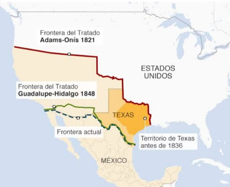
The border is a conventional line, that is, one that has been established by custom or according to norms, to mark the boundary of a state. Between the U.S. and Mexico, the Rio Grande River fulfills this function. But it was not always like this, because if we remember, both countries came into conflict over the territories of Texas, among others, at the end and beginning of the 1830s and 1840s.
Mexico had just recently emerged from a conflagration: the War of Independence, which lasted 11 years (from 1810 to 1821), which added to the social, economic and political unrest, finally led Antonio López de Santa Anna to sell these territories in 1845, thus configuring the current territory of Mexico as we know it, with the Rio Bravo River acting as a border.
The most crossed border in the world is precisely between Tijuana – a city that belongs to the Mexican state of Baja California – and San Diego, a city on the U.S. side. Mexico has been a crossing point for the enormous migration from Central and South America, and from other countries whose destination is the American dream.
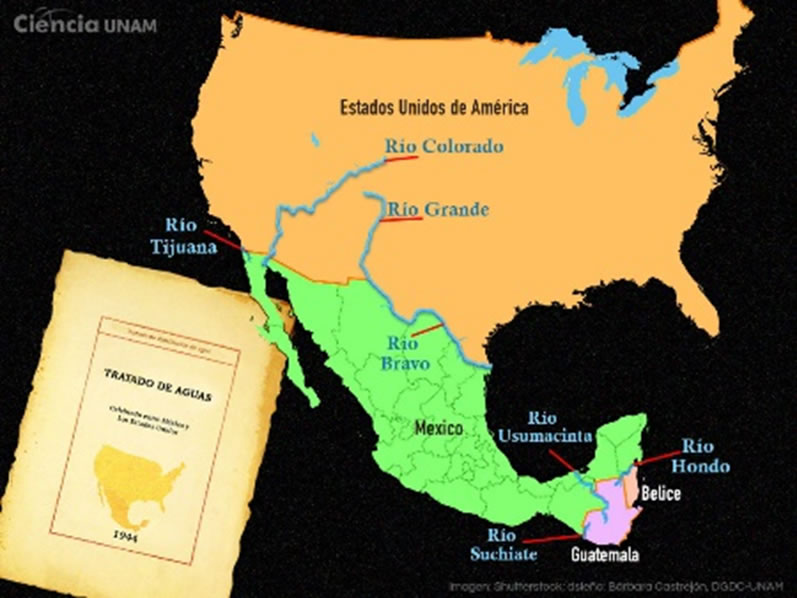
Image source: García (2020). https://ciencia.unam.mx/
To the north, Mexico has three transboundary river basins, meaning the territory whose waters flow into the same river, lake or sea: the Rio Bravo, the Colorado River and the Tijuana River; to the south, the Hondo River, which it shares with Belize, the Suchiate River and the Usumacinta River, which it shares with Guatemala, with which it signed a border treaty in 1882.
While with the USA there are treaties that are continuously revised, to the south it is not the same, it is only the legal recognition of the borders. Perhaps it is because the northern states are drier for both the U.S. and Mexico and are also dedicated to large-scale livestock farming, where water is an indispensable resource, while to the south there are greater water resources.
We will mention livestock activity as an example of why both countries (Mexico and the USA) are responsible for protecting water: this livestock activity, which shares a border with the USA, uses about 500,000 liters of water per year for a single cow; this consumption includes the planting of pastures; therefore, it is said that beef consumption is not sustainable in the future. The northern Mexican states with the most cattle raising activity are Chihuahua, Sinaloa, Coahuila and Tamaulipas; while on the southern side of the USA it is the state of Texas.
The use of rivers to mark borders is not exclusive to the division between countries; also within Mexican territory they have been used to mark limits between different populations, however, there may not be agreements between the flow of the river that is shared between populations and agreements on the maintenance of water quality, considering climatic changes, livestock and agricultural activity, population increase and deforestation.
It would be important to have treaties on the northern and southern borders of the country, and also within the states of the Mexican territory, to preserve the quality of water, since it is a resource that it is up to all of us to take care of and protect rather than considering it only an element of wealth generation or “someone’s” property.
It is very important to spread the information so that not only Mexico and its neighbors become aware of the protection of their rivers, since in the world there are more or less 145 countries that share basins, but only 40% have legal agreements only to regulate the flow they share.
References
BBC News. (s.f.). Cómo la disputa del río Nueces entre Texas y México desembocó en la pérdida de 55% del territorio mexicano. Recuperado de https://www.google.com/imgres?imgurl
García, L. (24 de febrero, 2020). Agua transfronteriza. Retos en las fronteras norte y sur de México. Ciudad de México, México: Ciencia UNAM-DGDCUNAM, Universidad Nacional Autónoma de México. Recuperado de https://ciencia.unam.mx
IMTA, Instituto Mexicano de Tecnología del Agua. (01 de agosto, 2019). ¿Qué es una cuenca? Recuperado de https://www.google.com/url?sa